Search
You Searched For
Search Results
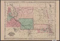
- Creator:
- Johnson, A. J. (Alvin Jewett), 1827-1884
- Published / Created:
- c1865.
- Call Number:
- 824 1865
- Container / Volume:
- BRBL_00570
- Image Count:
- 1
- Resource Type:
- Maps, Atlases & Globes
- Found in:
- Beinecke Rare Book and Manuscript Library > Johnson's Nebraska, Dakota, Idaho, and Montana.
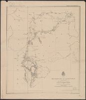
- Creator:
- Ludlow, William, 1843-1901
- Published / Created:
- [1874?]
- Call Number:
- 821 1874
- Container / Volume:
- BRBL_00566
- Image Count:
- 1
- Resource Type:
- Maps, Atlases & Globes
- Found in:
- Beinecke Rare Book and Manuscript Library > Map of a reconnaissance of the Black Hills, July and August, 1874, with troops under command of Lt. Col. G.A. Custer, 7th Cavalry / by Capt. Wm. Ludlow, Corps of Engineers.
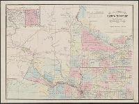
- Creator:
- Smith, B. M. (Byron M.)
- Published / Created:
- 1861
- Call Number:
- 821 1863
- Container / Volume:
- BRBL_00566
- Image Count:
- 1
- Resource Type:
- Maps, Atlases & Globes
- Found in:
- Beinecke Rare Book and Manuscript Library > Map of the ceded part of Dakota Territory : showing also portions of Minnesota, Iowa & Nebraska / compiled by B.M. Smith and A.J. Hill.
- Creator:
- Smith, B. M. (Byron M.)
- Published / Created:
- 1861
- Call Number:
- 821 1861
- Container / Volume:
- BRBL_00566
- Image Count:
- 1
- Resource Type:
- Maps, Atlases & Globes
- Found in:
- Beinecke Rare Book and Manuscript Library > Map of the ceded part of Dakota Territory : showing also portions of Minnesota, Iowa & Nebraska / compiled by B.M. Smith and A.J. Hill.
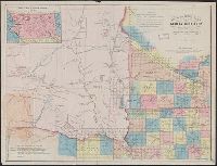
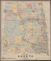
- Creator:
- Rand McNally and Company
- Published / Created:
- 1889?]
- Call Number:
- 821 1889
- Container / Volume:
- BRBL_00566
- Image Count:
- 1
- Resource Type:
- Maps, Atlases & Globes
- Found in:
- Beinecke Rare Book and Manuscript Library > Official map of Dakota / issued by the Department of Immigration and Statistics.
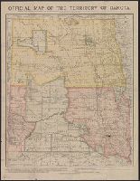
- Creator:
- Rand McNally and Company
- Published / Created:
- c1887.
- Call Number:
- 821 1887
- Container / Volume:
- BRBL_00566
- Image Count:
- 1
- Resource Type:
- Maps, Atlases & Globes
- Found in:
- Beinecke Rare Book and Manuscript Library > Official map of the territory of Dakota.
- Published / Created:
- 1872
- Call Number:
- 821 1872
- Container / Volume:
- BRBL_00566
- Image Count:
- 1
- Resource Type:
- Maps, Atlases & Globes
- Found in:
- Beinecke Rare Book and Manuscript Library > Rice's sectional map of Dakota Territory / draughted by Fred Sturnegk.
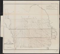
- Published / Created:
- 1876
- Call Number:
- 821 1876A
- Container / Volume:
- BRBL_00566
- Image Count:
- 1
- Resource Type:
- Maps, Atlases & Globes
- Found in:
- Beinecke Rare Book and Manuscript Library > Rice's sectional map of Dakota.
- Creator:
- United States. Surveyor General
- Published / Created:
- 1862
- Call Number:
- 815fcm 1862
- Container / Volume:
- BRBL_00561
- Image Count:
- 1
- Resource Type:
- Maps, Atlases & Globes
- Found in:
- Beinecke Rare Book and Manuscript Library > Sketch of the public surveys in Iowa and Dakota / Surveyor General's Office.
- Creator:
- United States. Surveyor General
- Published / Created:
- 1860
- Call Number:
- 815fcm 1860
- Container / Volume:
- BRBL_00561
- Image Count:
- 1
- Resource Type:
- Maps, Atlases & Globes
- Found in:
- Beinecke Rare Book and Manuscript Library > Sketch of the public surveys in Iowa and Dakota.